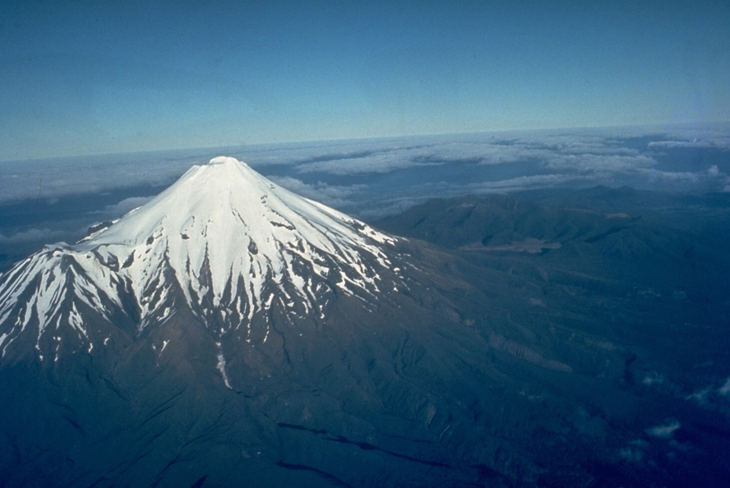
Symmetrical snow-capped cone of Mount Taranaki, New Zealand
Photo:Jim Cole
Volcano Dossier•GVP #241030
39.30°S, 174.07°E
Historical eruption
New Zealand→

Volcano Taranaki

A near-perfect 2,518 m cone on New Zealand's west coast, so symmetrical that it stood in for Mount Fuji in the film The Last Samurai. It last erupted around 1790, and in 2025 it was granted legal personhood, recognised in law as an ancestor of the region's Māori iwi.

Last eruption

1800

Historical eruption

Summit

2.5 km

Stratovolcano · Andesite / Basaltic Andesite

Activity

Normal Baseline

0 events (1.0x rate)

Interactive Volcano & Seismicity Map

Seismicity within 50 km radius, active VAAC ash plumes, and tectonic plate boundaries.

Recent seismicity within 50 km

107

0 events in the last 12 h within 25 km of the crater.

TimeMagnitudeEpicenter / PlaceDistance
11h agoM2.257 km SE of New Plymouth (New Zealand)38 km
2d agoM2.654 km SE of New Plymouth (New Zealand)33 km
2d agoM2.628 km E of New Plymouth (New Zealand)33 km
2d agoM1.861 km SE of New Plymouth (New Zealand)43 km
3d agoM2.569 km S of New Plymouth (New Zealand)41 km
3d agoM2.261 km SE of New Plymouth (New Zealand)41 km
4d agoM2.752 km SE of New Plymouth (New Zealand)34 km
5d agoM2.562 km NW of Whanganui (New Zealand)48 km
5d agoM2.557 km SE of New Plymouth (New Zealand)39 km
6d agoM2.558 km SE of New Plymouth (New Zealand)41 km
6d agoM2.759 km SE of New Plymouth (New Zealand)40 km
7d agoM2.855 km SE of New Plymouth (New Zealand)35 km
7d agoM2.561 km SE of New Plymouth (New Zealand)40 km
8d agoM2.661 km SE of New Plymouth (New Zealand)43 km
8d agoM2.061 km NW of Whanganui (New Zealand)48 km
8d agoM2.356 km S of New Plymouth (New Zealand)31 km
9d agoM2.7Near New Plymouth (New Zealand)27 km
10d agoM2.460 km SE of New Plymouth (New Zealand)42 km
10d agoM2.457 km SE of New Plymouth (New Zealand)37 km
11d agoM2.160 km SE of New Plymouth (New Zealand)41 km
12d agoM2.453 km SE of New Plymouth (New Zealand)37 km
12d agoM1.472 km W of Whanganui (New Zealand)47 km
13d agoM2.061 km SE of New Plymouth (New Zealand)41 km
13d agoM2.465 km S of New Plymouth (New Zealand)38 km
13d agoM2.1Off the coast of New Plymouth (38 km SW, New Zealand)32 km
Showing 25 of 107 earthquakes

Geological & Tectonic Profile

Stratovolcano

Taranaki is an active Stratovolcano formed in an active Subduction zone / Continental crust (> 25 km). Dominant lithology: Andesite / Basaltic Andesite.

Edifice TypeStratovolcano
Major rockAndesite / Basaltic Andesite
TectonicsSubduction zone
Volcanic ArcWestern North Island Volcanic Province

Volcano Dossier

VN #241030

Official catalogue parameters, coordinates, elevation and geotectonic classification.

Crater Coordinates-39.300°, 174.070°
Summit2.5 km
SubregionWestern North Island Volcanic Province
Catalog SourceSmithsonian GVP (#241030)

Authoritative Monitoring Infrastructure

All 18 Networks & VAAC →
Seismic ObservatoryGeoNet
GeoNet (GNS Science & EQC)
Official Portal
ICAO Aviation Ash Center
Wellington VAAC (MetService)
Wellington, New Zealand
VAAC Advisory Desk
Swarm telemetry correlated across 18 networks against a 30-day baseline.Read Science & Physics →
Regional Seismic Profile

North Island & Hikurangi Subduction

Explore live seismic monitoring, historical danger benchmarks, fault slip models and recurrence intervals for North Island & Hikurangi Subduction.

Open Regional Hub

Frequently Asked Questions (FAQ)

Verified scientific, operational, and emergency protocols

The most recent eruption of Taranaki recorded by the Smithsonian Global Volcanism Program was in 1800.

Catalogue: Smithsonian Institution, Global Volcanism Program.Smithsonian GVP profile