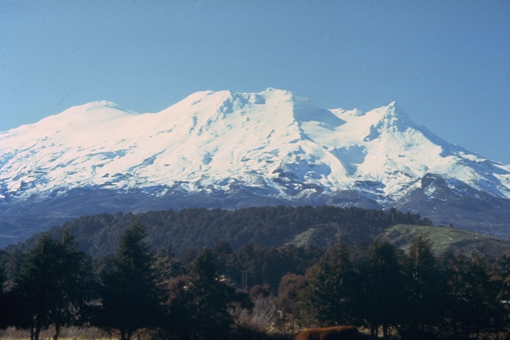
火山 ルアペフ
北島の最高峰で、ニュージーランドで最も活発な火山の一つ。山頂に火口湖があり、斜面にはスキー場があります。1953年には火口湖から流れ出たラハールが列車到着の数分前にタンギワイの鉄道橋を押し流し、151人が亡くなりました。現在は自動ラハール警報システムが湖を監視しています。
最新の噴火
2007
2000年以降に噴火
山頂標高
2.8 km
成層火山 · 安山岩 / 玄武岩質安山岩
活動度
平常ベースライン
1件の地震(通常の2.1倍)
インタラクティブな火山および地震活動マップ
半径50km以内の地震活動、活発なVAAC火山灰プルーム、テクトニックプレート境界。
半径50 km以内の最近の地震活動
過去12時間に火口から25 km以内で1回の地震。この火山の平常時の2.1倍の頻度です。
| 時刻 | マグニチュード | 震央・場所 | 距離 |
|---|---|---|---|
| 2h 前 | M1.9 | 15 km east of Taumarunui, New Zealand | 41 km |
| 2h 前 | M1.5 | 10 km south of Taumarunui, New Zealand | 42 km |
| 3h 前 | M2.1 | 20 km south-west of Taumarunui, New Zealand | 46 km |
| 8h 前 | M1.7 | 15 km north of Ohakune, New Zealand | 17 km |
| 18h 前 | M1.4 | 25 km north of Taihape, New Zealand | 25 km |
| 1d 前 | M2.9 | 5 km south of Taumarunui, New Zealand | 44 km |
| 2d 前 | M1.3 | 25 km north-west of Ohakune, New Zealand | 27 km |
| 2d 前 | M1.7 | 20 km north-west of Taihape, New Zealand | 28 km |
| 2d 前 | M1.4 | 30 km north-west of Ohakune, New Zealand | 42 km |
| 2d 前 | M1.5 | 35 km south-west of Taumarunui, New Zealand | 48 km |
| 2d 前 | M3.1 | 20 km north-west of Ohakune, New Zealand | 30 km |
| 3d 前 | M1.1 | 20 km north of Taihape, New Zealand | 27 km |
| 3d 前 | M2.0 | 15 km north of Taihape, New Zealand | 30 km |
| 3d 前 | M1.4 | 30 km north-west of Ohakune, New Zealand | 36 km |
| 3d 前 | M1.8 | 25 km west of Ohakune, New Zealand | 43 km |
| 4d 前 | M3.1 | 10 km south-west of Taumarunui, New Zealand | 50 km |
| 4d 前 | M3.1 | 30 km north-east of Taihape, New Zealand | 47 km |
| 4d 前 | M2.9 | 10 km south of Turangi, New Zealand | 26 km |
| 4d 前 | M1.2 | 20 km north-west of Ohakune, New Zealand | 23 km |
| 4d 前 | M2.6 | 5 km south-east of Taumarunui, New Zealand | 46 km |
| 4d 前 | M1.2 | 25 km south of Taumarunui, New Zealand | 32 km |
| 4d 前 | M1.8 | 20 km north-west of Taihape, New Zealand | 28 km |
| 4d 前 | M1.5 | 20 km north of Taihape, New Zealand | 25 km |
| 4d 前 | M1.2 | 20 km north of Ohakune, New Zealand | 20 km |
| 5d 前 | M1.0 | 25 km north of Taihape, New Zealand | 24 km |
| 5d 前 | M0.9 | 15 km north of Taihape, New Zealand | 29 km |
| 5d 前 | M0.8 | 20 km north-east of Ohakune, New Zealand | 0.9 km |
| 6d 前 | M1.2 | 10 km south of Taumarunui, New Zealand | 44 km |
| 6d 前 | M1.2 | 20 km north-west of Ohakune, New Zealand | 24 km |
| 6d 前 | M0.9 | 15 km north of Ohakune, New Zealand | 16 km |
| 7d 前 | M2.2 | 40 km north-west of Ohakune, New Zealand | 47 km |
| 7d 前 | M0.7 | 15 km north of Ohakune, New Zealand | 8.4 km |
| 7d 前 | M1.3 | 20 km north-west of Ohakune, New Zealand | 22 km |
| 8d 前 | M1.6 | 25 km west of Taihape, New Zealand | 47 km |
| 8d 前 | M0.3 | 20 km north of Taihape, New Zealand | 27 km |
| 8d 前 | M2.0 | Within 5 km of Taihape, New Zealand | 46 km |
| 8d 前 | M1.3 | 20 km north-east of Taihape, New Zealand | 47 km |
| 8d 前 | M0.7 | 30 km north of Taihape, New Zealand | 26 km |
| 9d 前 | M1.2 | 20 km north of Taihape, New Zealand | 27 km |
| 9d 前 | M0.8 | 20 km north-west of Taihape, New Zealand | 27 km |
| 9d 前 | M1.5 | Within 5 km of Turangi, New Zealand | 35 km |
| 9d 前 | M0.5 | 20 km east of Ohakune, New Zealand | 19 km |
| 9d 前 | M0.9 | 20 km north of Taihape, New Zealand | 26 km |
| 9d 前 | M0.7 | Within 5 km of Turangi, New Zealand | 34 km |
| 10d 前 | M0.8 | 15 km north of Ohakune, New Zealand | 16 km |
| 10d 前 | M1.3 | 25 km west of Ohakune, New Zealand | 41 km |
| 10d 前 | M2.0 | 20 km north-west of Ohakune, New Zealand | 28 km |
| 10d 前 | M1.2 | 10 km south of Taumarunui, New Zealand | 46 km |
| 10d 前 | M2.2 | 10 km east of Taumarunui, New Zealand | 50 km |
| 10d 前 | M1.4 | 15 km north-west of Taihape, New Zealand | 29 km |
| 11d 前 | M0.7 | 20 km north of Taihape, New Zealand | 27 km |
| 11d 前 | M2.4 | 20 km north-west of Ohakune, New Zealand | 23 km |
| 11d 前 | M1.3 | 25 km south-west of Ohakune, New Zealand | 47 km |
| 11d 前 | M1.4 | 20 km north-west of Taihape, New Zealand | 28 km |
| 11d 前 | M1.5 | 20 km north-west of Taihape, New Zealand | 26 km |
| 11d 前 | M1.9 | 15 km north of Taihape, New Zealand | 35 km |
| 11d 前 | M1.4 | 10 km south-east of Turangi, New Zealand | 37 km |
| 11d 前 | M2.3 | 35 km south-west of Taumarunui, New Zealand | 45 km |
| 11d 前 | M1.8 | 10 km west of Turangi, New Zealand | 35 km |
| 11d 前 | M1.8 | 20 km north-west of Taihape, New Zealand | 28 km |
| 11d 前 | M0.9 | 20 km north of Taihape, New Zealand | 28 km |
| 11d 前 | M1.7 | 5 km south-east of Taumarunui, New Zealand | 44 km |
| 11d 前 | M1.0 | 10 km south of Taumarunui, New Zealand | 44 km |
| 12d 前 | M1.4 | 15 km north of Taihape, New Zealand | 29 km |
| 12d 前 | M1.3 | 20 km north-west of Taihape, New Zealand | 28 km |
| 12d 前 | M2.0 | 10 km north of Taihape, New Zealand | 39 km |
| 12d 前 | M1.6 | 40 km south-east of Turangi, New Zealand | 46 km |
| 12d 前 | M1.1 | 20 km north of Taihape, New Zealand | 26 km |
| 13d 前 | M1.3 | 10 km south of Turangi, New Zealand | 25 km |
| 13d 前 | M1.0 | 20 km north of Ohakune, New Zealand | 18 km |
| 14d 前 | M0.5 | 15 km north-west of Taihape, New Zealand | 29 km |
| 15d 前 | M0.7 | 20 km north-west of Taihape, New Zealand | 28 km |
| 15d 前 | M1.5 | 20 km north-east of Taihape, New Zealand | 48 km |
| 15d 前 | M1.0 | 20 km south-west of Turangi, New Zealand | 15 km |
| 15d 前 | M2.5 | 10 km south-east of Taumarunui, New Zealand | 39 km |
| 16d 前 | M1.1 | 25 km north-east of Ohakune, New Zealand | 11 km |
| 16d 前 | M1.3 | 20 km north-west of Ohakune, New Zealand | 28 km |
| 17d 前 | M0.5 | 35 km south of Turangi, New Zealand | 31 km |
| 18d 前 | M1.3 | 35 km north-east of Taihape, New Zealand | 39 km |
| 18d 前 | M0.7 | 20 km north of Taihape, New Zealand | 25 km |
| 19d 前 | M2.5 | 25 km south of Taumarunui, New Zealand | 39 km |
| 19d 前 | M1.6 | 5 km south-west of Taumarunui, New Zealand | 48 km |
| 19d 前 | M1.3 | 20 km north-west of Ohakune, New Zealand | 24 km |
| 19d 前 | M1.1 | 30 km south of Turangi, New Zealand | 26 km |
| 19d 前 | M1.0 | 15 km north of Ohakune, New Zealand | 16 km |
| 19d 前 | M0.8 | 20 km north of Ohakune, New Zealand | 21 km |
| 20d 前 | M0.7 | 20 km north of Ohakune, New Zealand | 21 km |
| 20d 前 | M1.3 | 20 km south of Turangi, New Zealand | 25 km |
| 21d 前 | M1.9 | 20 km north-west of Ohakune, New Zealand | 23 km |
| 21d 前 | M1.4 | 10 km south-west of Taumarunui, New Zealand | 49 km |
| 21d 前 | M1.6 | 20 km north-west of Ohakune, New Zealand | 32 km |
| 21d 前 | M2.3 | 10 km south of Taumarunui, New Zealand | 44 km |
| 21d 前 | M1.5 | 15 km south of Taumarunui, New Zealand | 43 km |
| 22d 前 | M1.6 | 10 km south of Taumarunui, New Zealand | 41 km |
| 22d 前 | M1.3 | 5 km south of Taumarunui, New Zealand | 46 km |
| 22d 前 | M4.2 | 10 km south-west of Taumarunui, New Zealand | 50 km |
| 22d 前 | M2.5 | 10 km south-west of Turangi, New Zealand | 26 km |
| 22d 前 | M0.4 | 5 km south-east of Turangi, New Zealand | 33 km |
| 22d 前 | M0.5 | 20 km north-west of Taihape, New Zealand | 26 km |
| 22d 前 | M2.1 | 10 km south of Ohakune, New Zealand | 27 km |
| 22d 前 | M0.6 | 25 km north of Taihape, New Zealand | 26 km |
| 23d 前 | M1.5 | 35 km north-east of Taihape, New Zealand | 36 km |
| 23d 前 | M1.1 | 20 km south-east of Taumarunui, New Zealand | 31 km |
| 24d 前 | M1.5 | 5 km south-west of Taumarunui, New Zealand | 49 km |
| 24d 前 | M1.9 | 5 km north of Taihape, New Zealand | 43 km |
| 24d 前 | M2.8 | 45 km south-east of Turangi, New Zealand | 46 km |
| 24d 前 | M2.0 | 25 km north-west of Ohakune, New Zealand | 32 km |
| 24d 前 | M1.2 | 35 km south-east of Turangi, New Zealand | 45 km |
| 24d 前 | M1.4 | 20 km north of Taihape, New Zealand | 26 km |
| 25d 前 | M1.3 | 10 km south of Ohakune, New Zealand | 31 km |
| 25d 前 | M1.3 | 10 km south-west of Ohakune, New Zealand | 34 km |
| 25d 前 | M1.4 | 20 km north of Taihape, New Zealand | 26 km |
| 25d 前 | M0.7 | 25 km north of Ohakune, New Zealand | 15 km |
| 25d 前 | M0.4 | 20 km north of Taihape, New Zealand | 28 km |
| 25d 前 | M2.2 | 15 km south of Ohakune, New Zealand | 34 km |
| 25d 前 | M1.5 | 25 km south of Ohakune, New Zealand | 49 km |
| 25d 前 | M1.4 | 10 km south-west of Taumarunui, New Zealand | 49 km |
| 25d 前 | M2.0 | 20 km east of Taumarunui, New Zealand | 42 km |
| 25d 前 | M2.1 | 25 km south of Ohakune, New Zealand | 46 km |
| 26d 前 | M1.0 | 35 km south of Turangi, New Zealand | 33 km |
| 26d 前 | M1.5 | 10 km north-east of Taihape, New Zealand | 47 km |
| 26d 前 | M1.6 | 25 km east of Ohakune, New Zealand | 20 km |
| 26d 前 | M2.1 | 30 km south of Turangi, New Zealand | 23 km |
| 26d 前 | M2.1 | 10 km south-west of Turangi, New Zealand | 25 km |
| 26d 前 | M0.8 | 35 km south-east of Turangi, New Zealand | 42 km |
| 27d 前 | M1.6 | 15 km north-east of Ohakune, New Zealand | 3.0 km |
| 27d 前 | M2.1 | 35 km north-west of Ohakune, New Zealand | 47 km |
| 27d 前 | M1.8 | 30 km north-west of Ohakune, New Zealand | 40 km |
| 27d 前 | M1.5 | 25 km north of Ohakune, New Zealand | 17 km |
| 27d 前 | M1.4 | 25 km north of Ohakune, New Zealand | 23 km |
| 28d 前 | M2.1 | 15 km south of Turangi, New Zealand | 29 km |
| 28d 前 | M1.3 | 5 km north-east of Ohakune, New Zealand | 12 km |
| 29d 前 | M0.9 | 15 km south-west of Turangi, New Zealand | 18 km |
| 29d 前 | M1.0 | 20 km east of Ohakune, New Zealand | 12 km |
| 29d 前 | M2.4 | 25 km south-west of Ohakune, New Zealand | 48 km |
| 29d 前 | M2.1 | 5 km south of Taumarunui, New Zealand | 44 km |
| 29d 前 | M1.2 | 15 km south-west of Taumarunui, New Zealand | 47 km |
| 30d 前 | M1.4 | 25 km south-west of Taumarunui, New Zealand | 43 km |
| 30d 前 | M0.9 | 10 km south of Taumarunui, New Zealand | 39 km |
| 30d 前 | M0.8 | 5 km north of Ohakune, New Zealand | 14 km |
| 30d 前 | M2.2 | 25 km south-west of Ohakune, New Zealand | 48 km |
| 30d 前 | M1.0 | 20 km north-west of Ohakune, New Zealand | 23 km |
| 30d 前 | M0.8 | 25 km north-west of Ohakune, New Zealand | 31 km |
| 31d 前 | M0.8 | 25 km north-west of Ohakune, New Zealand | 26 km |
| 31d 前 | M1.0 | 15 km north of Ohakune, New Zealand | 11 km |
| 31d 前 | M1.0 | 25 km north-west of Turangi, New Zealand | 49 km |
| 31d 前 | M1.5 | 30 km south-west of Taumarunui, New Zealand | 44 km |
| 31d 前 | M1.6 | 15 km north of Turangi, New Zealand | 49 km |
| 31d 前 | M3.0 | 15 km north of Ohakune, New Zealand | 13 km |
| 31d 前 | M1.4 | 10 km south of Taumarunui, New Zealand | 43 km |
| 32d 前 | M2.9 | 20 km south of Taumarunui, New Zealand | 33 km |
| 33d 前 | M0.8 | 15 km west of Turangi, New Zealand | 24 km |
| 33d 前 | M3.5 | 35 km north-east of Taihape, New Zealand | 45 km |
| 33d 前 | M2.3 | 10 km south of Taumarunui, New Zealand | 42 km |
| 33d 前 | M2.8 | 10 km south of Taumarunui, New Zealand | 42 km |
| 34d 前 | M0.8 | 20 km north-west of Taihape, New Zealand | 27 km |
| 34d 前 | M1.7 | 15 km south-west of Turangi, New Zealand | 18 km |
| 34d 前 | M2.3 | 25 km south of Taumarunui, New Zealand | 29 km |
| 34d 前 | M1.3 | 10 km north-west of Turangi, New Zealand | 44 km |
| 35d 前 | M1.8 | 15 km north-west of Taihape, New Zealand | 32 km |
| 35d 前 | M1.3 | 25 km west of Ohakune, New Zealand | 43 km |
| 35d 前 | M1.5 | 30 km south of Taumarunui, New Zealand | 33 km |
| 35d 前 | M1.9 | 25 km south of Turangi, New Zealand | 20 km |
| 35d 前 | M1.0 | 20 km south-east of Taumarunui, New Zealand | 31 km |
| 35d 前 | M0.7 | 10 km east of Taumarunui, New Zealand | 44 km |
| 35d 前 | M1.6 | 20 km north of Taihape, New Zealand | 27 km |
| 36d 前 | M1.3 | 10 km north of Taihape, New Zealand | 34 km |
| 36d 前 | M2.6 | 15 km south-west of Ohakune, New Zealand | 36 km |
| 36d 前 | M1.1 | 20 km north-west of Ohakune, New Zealand | 25 km |
| 36d 前 | M2.3 | 20 km south-east of Ohakune, New Zealand | 33 km |
| 36d 前 | M1.5 | 20 km north-west of Ohakune, New Zealand | 23 km |
| 36d 前 | M1.9 | 25 km south-west of Taumarunui, New Zealand | 47 km |
| 37d 前 | M1.4 | 10 km south-west of Taumarunui, New Zealand | 47 km |
| 37d 前 | M1.6 | 10 km south-west of Taumarunui, New Zealand | 45 km |
| 37d 前 | M2.6 | 25 km north of Ohakune, New Zealand | 18 km |
| 37d 前 | M2.3 | 20 km south-east of Ohakune, New Zealand | 28 km |
| 37d 前 | M1.4 | 20 km north-west of Ohakune, New Zealand | 24 km |
| 37d 前 | M1.2 | 25 km north-east of Ohakune, New Zealand | 9.4 km |
| 38d 前 | M1.7 | 15 km north-west of Taihape, New Zealand | 32 km |
地質およびテクトニックプロファイル
成層火山ルアペフは沈み込み帯 / 大陸地殻 (> 25 km)で形成された活発な成層火山です。主要岩石: 安山岩 / 玄武岩質安山岩。
火山形態成層火山
主要岩石安山岩 / 玄武岩質安山岩
テクトニクス沈み込み帯
火山弧Taupo火山弧
火山カルテ
VN #241100公式カタログの諸元、座標、標高、地質構造分類。
国ニュージーランド
火口の座標-39.280°, 175.570°
山頂標高2.8 km
サブリージョンTaupo火山弧
カタログ提供元Smithsonian GVP (#241100)
よくあるご質問(FAQ)
検証済みの科学的・運用面・緊急対応プロトコル
スミソニアン Global Volcanism Program が記録するルアペフの直近の噴火は2007年です。
カタログ: スミソニアン協会 Global Volcanism Program。Smithsonian GVP のページ