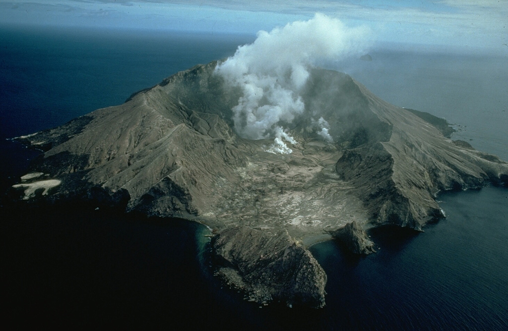
Vulkan Whakaari / White Island
Neuseelands aktivster Kegelvulkan, eine Insel, die größtenteils aus einem untergetauchten Krater besteht. Ein plötzlicher dampfgetriebener Ausbruch im Dezember 2019 tötete 22 Menschen, die den Kraterboden besuchten, nahezu ohne Vorwarnung.
Letzter Ausbruch
Ausbruch seit 2000
Gipfel
Stratovulkan · Andesit / Basaltandesit
Aktivität
1 Ereignisse (3.2-fache Rate)
Interaktive Karte von Vulkan & Seismizität
Seismizität im Umkreis von 50 km, aktive VAAC-Aschewolken und tektonische Plattengrenzen.
Aktuelle Seismizität im Umkreis von 50 km
1 Ereignisse in den letzten 12 h im Umkreis von 25 km um den Krater.Das 3.2-Fache der üblichen Rate dieses Vulkans.
| Zeit | Magnitude | Epizentrum / Ort | Entfernung |
|---|---|---|---|
| 4h her | M3.3 | 35 km north-west of Te Kaha, New Zealand | 17 km |
| 15h her | M1.8 | 35 km north-west of Te Kaha, New Zealand | 14 km |
| 23h her | M2.9 | 30 km north of Whakatane, New Zealand | 31 km |
| 1d her | M2.1 | 60 km north of Whakatane, New Zealand | 19 km |
| 2d her | M2.3 | 60 km north-west of Te Kaha, New Zealand | 23 km |
| 2d her | M2.4 | 60 km north-west of Te Kaha, New Zealand | 21 km |
| 3d her | M2.8 | 45 km north-west of Te Kaha, New Zealand | 24 km |
| 4d her | M2.3 | 25 km north-west of Te Kaha, New Zealand | 26 km |
| 5d her | M2.1 | 10 km north-west of Whakatane, New Zealand | 47 km |
| 5d her | M2.2 | 80 km north-east of Tauranga, New Zealand | 45 km |
| 5d her | M1.7 | 5 km north-west of Whakatane, New Zealand | 48 km |
| 5d her | M2.3 | 60 km north-west of Te Kaha, New Zealand | 29 km |
| 5d her | M3.4 | 65 km north of Whakatane, New Zealand | 26 km |
| 5d her | M3.5 | 65 km north-west of Te Kaha, New Zealand | 40 km |
| 6d her | M2.4 | 75 km north-west of Te Kaha, New Zealand | 33 km |
| 6d her | M2.4 | 70 km north-west of Te Kaha, New Zealand | 28 km |
| 6d her | M2.3 | 80 km north-west of Te Kaha, New Zealand | 36 km |
| 6d her | M2.1 | 55 km north-west of Te Kaha, New Zealand | 12 km |
| 6d her | M2.3 | 45 km north-west of Te Kaha, New Zealand | 23 km |
| 10d her | M2.1 | 50 km east of Tauranga, New Zealand | 40 km |
| 11d her | M3.3 | 55 km north-west of Te Kaha, New Zealand | 20 km |
| 11d her | M3.2 | NORTH ISLAND OF NEW ZEALAND (GNS) | 28 km |
| 11d her | M2.3 | 60 km north-west of Te Kaha, New Zealand | 26 km |
| 11d her | M2.5 | 55 km north-west of Te Kaha, New Zealand | 29 km |
| 11d her | M2.0 | 50 km north-west of Te Kaha, New Zealand | 3.9 km |
| 12d her | M3.1 | 10 km north-east of Whakatane, New Zealand | 42 km |
| 12d her | M4.2 | 65 km north of Te Kaha, New Zealand | 43 km |
| 12d her | M2.7 | 70 km north-east of Tauranga, New Zealand | 48 km |
| 13d her | M2.2 | 60 km north-west of Te Kaha, New Zealand | 25 km |
| 14d her | M2.7 | 30 km north of Te Kaha, New Zealand | 47 km |
| 14d her | M2.1 | 60 km north of Te Kaha, New Zealand | 38 km |
| 14d her | M2.0 | 10 km north of Whakatane, New Zealand | 41 km |
| 14d her | M2.7 | 10 km north of Whakatane, New Zealand | 41 km |
| 14d her | M2.5 | 15 km north of Whakatane, New Zealand | 42 km |
| 14d her | M2.5 | 15 km north of Whakatane, New Zealand | 41 km |
| 14d her | M2.7 | 10 km north of Whakatane, New Zealand | 42 km |
| 14d her | M2.9 | 15 km north of Whakatane, New Zealand | 40 km |
| 16d her | M2.1 | 40 km north-west of Te Kaha, New Zealand | 7.8 km |
| 16d her | M2.4 | 55 km north of Whakatane, New Zealand | 8.8 km |
| 17d her | M2.5 | 20 km south-west of Te Kaha, New Zealand | 49 km |
| 17d her | M2.2 | 20 km south-west of Te Kaha, New Zealand | 48 km |
| 17d her | M1.8 | 15 km north of Whakatane, New Zealand | 38 km |
| 17d her | M2.1 | 15 km north of Whakatane, New Zealand | 39 km |
| 17d her | M1.9 | 15 km north of Whakatane, New Zealand | 39 km |
| 17d her | M2.1 | 10 km north of Whakatane, New Zealand | 40 km |
| 17d her | M2.9 | 15 km north of Whakatane, New Zealand | 39 km |
| 18d her | M2.4 | 15 km north of Whakatane, New Zealand | 39 km |
| 18d her | M2.5 | 15 km north of Whakatane, New Zealand | 40 km |
| 18d her | M2.4 | 10 km north of Whakatane, New Zealand | 41 km |
| 18d her | M2.7 | 45 km east of Tauranga, New Zealand | 43 km |
| 18d her | M2.3 | 40 km north of Whakatane, New Zealand | 21 km |
| 18d her | M2.6 | 70 km north of Te Kaha, New Zealand | 48 km |
| 19d her | M1.9 | 15 km north of Whakatane, New Zealand | 37 km |
| 20d her | M2.3 | 10 km west of Te Kaha, New Zealand | 44 km |
| 20d her | M2.7 | 55 km north-east of Tauranga, New Zealand | 48 km |
| 20d her | M2.4 | 10 km west of Te Kaha, New Zealand | 41 km |
| 21d her | M2.3 | 55 km north of Whakatane, New Zealand | 14 km |
| 22d her | M2.0 | 65 km north-west of Te Kaha, New Zealand | 24 km |
| 22d her | M2.2 | 65 km north of Whakatane, New Zealand | 29 km |
| 23d her | M1.8 | 30 km north of Te Kaha, New Zealand | 32 km |
| 24d her | M2.5 | 5 km east of Whakatane, New Zealand | 50 km |
| 25d her | M2.5 | 20 km north of Whakatane, New Zealand | 29 km |
| 25d her | M1.8 | 60 km north of Whakatane, New Zealand | 20 km |
| 25d her | M2.8 | 70 km north-east of Tauranga, New Zealand | 46 km |
| 26d her | M1.8 | 25 km north-west of Whakatane, New Zealand | 46 km |
| 27d her | M2.0 | 45 km north of Whakatane, New Zealand | 11 km |
| 28d her | M2.6 | 85 km north-east of Tauranga, New Zealand | 44 km |
| 28d her | M2.6 | 55 km north of Whakatane, New Zealand | 20 km |
| 29d her | M2.5 | 35 km west of Te Kaha, New Zealand | 19 km |
| 29d her | M2.5 | 80 km north-west of Te Kaha, New Zealand | 46 km |
| 30d her | M2.3 | 45 km east of Tauranga, New Zealand | 43 km |
| 30d her | M2.6 | 40 km north-west of Te Kaha, New Zealand | 7.3 km |
| 30d her | M2.6 | 45 km north-west of Te Kaha, New Zealand | 5.7 km |
| 30d her | M2.3 | 70 km north-west of Te Kaha, New Zealand | 39 km |
| 30d her | M2.4 | 50 km north of Whakatane, New Zealand | 8.6 km |
| 30d her | M2.7 | 50 km north-west of Te Kaha, New Zealand | 8.5 km |
| 30d her | M2.6 | 50 km north-west of Te Kaha, New Zealand | 5.3 km |
| 30d her | M3.0 | 60 km north of Whakatane, New Zealand | 12 km |
| 30d her | M2.3 | 15 km north of Opotiki, New Zealand | 41 km |
| 31d her | M3.4 | 70 km north-west of Te Kaha, New Zealand | 41 km |
| 31d her | M2.2 | 75 km north-west of Te Kaha, New Zealand | 33 km |
| 32d her | M3.9 | Bay of Plenty | 39 km |
| 32d her | M3.9 | 15 km north of Whakatane, New Zealand | 39 km |
| 32d her | M4.0 | Bay of Plenty | 17 km |
| 32d her | M4.0 | 35 km north of Whakatane, New Zealand | 17 km |
| 33d her | M2.1 | 60 km north-east of Tauranga, New Zealand | 49 km |
| 33d her | M2.2 | 45 km north of Whakatane, New Zealand | 7.7 km |
| 33d her | M2.0 | 75 km north of Whakatane, New Zealand | 30 km |
| 34d her | M2.5 | 50 km north of Whakatane, New Zealand | 6.8 km |
| 34d her | M2.4 | 55 km north of Whakatane, New Zealand | 8.1 km |
| 34d her | M2.7 | 50 km north of Whakatane, New Zealand | 10 km |
| 34d her | M1.8 | 20 km north of Opotiki, New Zealand | 35 km |
| 35d her | M2.1 | 5 km north-west of Te Kaha, New Zealand | 42 km |
| 36d her | M3.6 | 60 km north of Whakatane, New Zealand | 32 km |
| 36d her | M2.1 | 75 km north-west of Te Kaha, New Zealand | 36 km |
| 36d her | M2.2 | 80 km north-west of Te Kaha, New Zealand | 49 km |
| 37d her | M2.5 | 30 km north of Whakatane, New Zealand | 19 km |
| 40d her | M2.5 | 50 km north-west of Te Kaha, New Zealand | 11 km |
| 40d her | M2.9 | 50 km north-west of Te Kaha, New Zealand | 12 km |
| 40d her | M2.4 | 55 km north-east of Tauranga, New Zealand | 37 km |
| 41d her | M2.4 | 75 km north of Whakatane, New Zealand | 35 km |
| 41d her | M2.8 | 15 km north-west of Whakatane, New Zealand | 48 km |
| 41d her | M2.2 | 20 km north of Te Kaha, New Zealand | 44 km |
| 43d her | M2.3 | 50 km north-west of Te Kaha, New Zealand | 24 km |
| 44d her | M2.2 | 10 km west of Te Kaha, New Zealand | 40 km |
| 44d her | M1.2 | 15 km north-east of Whakatane, New Zealand | 37 km |
| 46d her | M2.0 | 20 km north of Te Kaha, New Zealand | 43 km |
| 47d her | M2.6 | 85 km north-west of Te Kaha, New Zealand | 46 km |
| 48d her | M2.3 | 55 km north of Whakatane, New Zealand | 8.4 km |
| 48d her | M2.5 | 30 km north of Whakatane, New Zealand | 27 km |
| 48d her | M2.0 | 25 km north of Whakatane, New Zealand | 29 km |
| 49d her | M2.0 | 10 km north of Te Kaha, New Zealand | 46 km |
| 49d her | M3.2 | 55 km north-west of Te Kaha, New Zealand | 32 km |
| 49d her | M2.3 | 40 km north-west of Te Kaha, New Zealand | 28 km |
| 49d her | M3.3 | 55 km north-west of Te Kaha, New Zealand | 32 km |
| 49d her | M2.5 | 60 km north-east of Tauranga, New Zealand | 44 km |
| 50d her | M3.6 | 25 km west of Te Kaha, New Zealand | 35 km |
| 50d her | M2.4 | 55 km north of Whakatane, New Zealand | 13 km |
| 51d her | M1.4 | 20 km north-east of Opotiki, New Zealand | 46 km |
| 51d her | M2.4 | 75 km north-east of Tauranga, New Zealand | 42 km |
| 51d her | M2.3 | 10 km south-west of Te Kaha, New Zealand | 49 km |
| 53d her | M2.4 | 30 km north of Whakatane, New Zealand | 22 km |
| 53d her | M2.1 | 30 km north of Whakatane, New Zealand | 21 km |
| 54d her | M2.0 | 40 km east of Tauranga, New Zealand | 49 km |
| 54d her | M2.6 | Raukumara Plain | 39 km |
| 55d her | M3.3 | Bay of Plenty | 31 km |
| 59d her | M3.0 | Bay of Plenty | 25 km |
| 59d her | M3.4 | Bay of Plenty | 46 km |
| 61d her | M2.7 | Bay of Plenty | 28 km |
| 62d her | M2.8 | Bay of Plenty | 37 km |
| 67d her | M3.1 | Bay of Plenty | 20 km |
| 68d her | M3.0 | Bay of Plenty | 11 km |
| 69d her | M3.8 | Raukumara Plain | 47 km |
| 69d her | M2.9 | Bay of Plenty | 21 km |
| 72d her | M3.4 | Bay of Plenty | 42 km |
| 72d her | M3.1 | Bay of Plenty | 21 km |
| 73d her | M2.7 | Bay of Plenty | 26 km |
| 77d her | M2.5 | Bay of Plenty | 24 km |
| 79d her | M3.0 | Bay of Plenty | 20 km |
| 80d her | M2.5 | Bay of Plenty | 19 km |
| 80d her | M2.6 | Bay of Plenty | 16 km |
| 80d her | M4.7 | 45 km north of Te Kaha | 46 km |
| 83d her | M3.6 | Bay of Plenty | 28 km |
| 83d her | M2.7 | Raukumara Plain | 49 km |
| 83d her | M2.7 | Bay of Plenty | 22 km |
| 87d her | M2.7 | Bay of Plenty | 7.2 km |
| 89d her | M2.6 | Bay of Plenty | 10 km |
Geologisches & tektonisches Profil
StratovulkanWhakaari / White Island ist ein aktiver Vulkan vom Typ Stratovulkan in der tektonischen Umgebung Subduktionszone / kontinentale Kruste (> 25 km). Vorherrschendes Gestein: Andesit / Basaltandesit.
Vulkan-Dossier
VN #241040Offizielle Katalogparameter, Koordinaten, Höhe und geotektonische Einordnung.
Maßgebliche Überwachungsinfrastruktur
Nordinsel & Hikurangi-Subduktion
Entdecken Sie für Nordinsel & Hikurangi-Subduktion die seismische Live-Überwachung, historische Gefahrenvergleiche, Versatzmodelle der Verwerfungen und Wiederkehrintervalle.
Regionales Zentrum öffnenHäufig gestellte Fragen (FAQ)
Geprüfte wissenschaftliche, operative und Notfallprotokolle
Katalog: Smithsonian Institution, Global Volcanism Program.Profil beim Smithsonian GVP